The Jarrells of Floyd County, Kentucky Jarrell Landholdings |
|
Article sections on the landholdings of:
|
| FamilySearch is generally the best
online source for Floyd County land records; login is required, but
registration is free and this is a safe site with no
downside to signing up. Finding an individual record is rather
complex because of the archaic organization system, but it gets
easier with experience. Land grants (also called patents) were grants of not-previously-owned land to an individual. The Kentucky Land Grants is a searchable online book with a typed, alphabetical list of all Kentucky land grants from 1782-1924 in several categories. Warrants were not free; they were sold at a price of $20 per 100 acres (Kentucky Land Grants pg 9). The Old Kentucky Grants and Kentucky Land warrants sections are the most relevant to our early Floyd County Jarrells. I looked for relevant records using spelling variations starting with Jar-, Jer-, Gar-, Ger- and Fitz. Page 349 of the book shows an 1804 deed in Muhlenberg County KY located at Jarrells Creek, indicating that Jarrells were in western Kentucky by this early date. Page 558 shows that two land warrants were issued to Ambrose Garrell in Floyd County in 1838. The only entries that look relevant to William, Susannah and their children are on page 604. It shows that Carrel Jarrel had a warrant for 50 acres on Puter Creek in 1822, and Ansel Jarrel had a warrant for 50 acres on Peter Creek in 1823. They probably mean Prater Creek in both cases - old documents are hard to read, and it helps to know the family history. It also shows a warrant for 100 acres to Carroll Jarrell on Layner branch of Beaver Creek in 1839. And that's all - nothing for William Jarrell. Subsequent sales of land that belonged to an individual were recorded in the Floyd County deed records. But the deed index pages for Jarrell grantees (buyers) and grantors (sellers) shows that there are only a handful of Jarrell-related deeds before 1850, and none before 1815. There are no relevant results under Jer-, Gar-, Ger- and Fitz. William and Susannah Jarrell moved to Floyd County with their children around 1802, and a courthouse fire in 1810 may have wiped out any earlier deed records that existed. This probably didn't affect the land grant records, which came from the state and were stored in the state land office. But overall it looks like the family owned little or no land before 1810. It's not easy to determine the land's location on the deeds that survive. Survey descriptions are rather vague and often use non-permanent reference points like trees to mark the location of a corner. The Floyd County surveys tend to be even vaguer than the ones in Virginia, and it's often impossible to glean enough information to draw the boundaries of the parcel or find an approximate location on a map. Furthermore, Floyd County decided to modernize their records sometime after the invention of the typewriter in 1867. The original handwritten documents were replaced by typed transcripts, and the original documents are no longer available. Some of these documents are confusing, and we can't tell whether the problem lies with the original or the accuracy of the transcript. Handwritten documents can be very hard to read, and some words might be interpreted differently by someone who was more familiar with the landowner. There are some cases where we can guess at what was actually meant, but most of the time we're at the mercy of the typist. Surveys were conducted when a land grant was issued, but not for a later sale unless the need arose. Survey maps were kept in a different book than the other records, and the survey books don't have an index. The original survey records have not been replaced with typed transcripts, which is good. But they also aren't particularly well organized, going roughly by date, and one must often leaf through many pages of hard-to-read material to find a specific survey. But if one can find the surveyor's map and knows the approximate location of the land, it's often possible to find a "best fit" location for the parcel on a topographic map. The region is very hilly, and people generally wanted land in the creek bottoms not on the slopes. It looks like the records after 1810 are incomplete; there are times when someone sells a piece of land with no record of ever acquiring it, or a piece of land has obviously changed hands with no record of the transaction. There is an overall impression that Floyd County in this time period was not a very sophisticated place in terms of understanding and enforcing the finer points of the law, including real estate transactions and inheritance law. There may have been many transactions that were never recorded at all. This article presents information on some Jarrell landholdings whose location could be identified. |
|
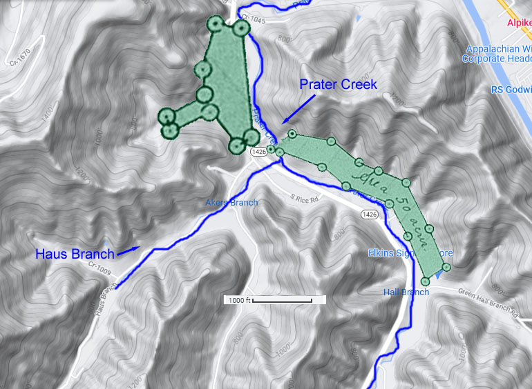
Location of Susannah Parks Jarrell's land. This article assumes that the reader is familiar with the early Floyd County Jarrells; if not, the family tree article has information.
The surveys for both parcels state that the properties are on Prater Creek. The rest of the description is too vague to identify the land's location on a modern map. But fortunately, an 1832 sale of part of the frog (Floyd County Deeds Book C page 358) specifies that it's on Hawses Branch (modern name=Haus Branch), and everything falls into place after that. There's really only one place on the map that these parcels can fit.This is not the family's only landholding in this area. Floyd County Deeds Book A page 390 shows William Junior buying 50 acres at the mouth of Prater Creek in 1816, a bit north of his mother's future land, and Floyd County Deeds Book B page 170 shows him selling it in 1820. An indenture related to the purchase is mentioned in the Annals of Floyd County page 32. Floyd County Deeds Book B page 60 shows Carroll Jarrell buying 50 acres straddling Prater Creek in 1819, but the details in the survey are insufficient to determine the precise location. He sold this land to Alexander Clark in 1828 (Floyd County Deeds Book C page 111), which helps explain how members of the Clark family came to be on the deed for the sale of the snake in 1834. They had previous land dealings with the Jarrells. The Kentucky Land Grants shows Carrel Jarrel with a warrant for 50 acres on "Puter" Creek in 1822, and Ansel Jarrel with 50 acres on "Peter" Creek in 1823. These creeks don't seem to exist, so it probably means Prater in both cases. We don't know what became of these parcels, so we can't tell whether the warrants were ever exercised. A warrant is the first step in acquiring land, but other steps have to be completed for the warrant to result in actual land ownership. An 1823 survey for was done for Ansel on Prater Creek however. One third of the frog was sold in 1832 but we don't know what became of the rest of it. It must have been sold or transferred at some point before or after Susannah's death, but there are no known records. The 1832 sale is mysterious; the sellers are Mary and Thomas Gerrell, who are clearly related to Susannah but don't appear to be husband and wife, and the buyer is Rewel (Ruel) Gerrell, Susannah's grandson. One interpretation is that Mary and Thomas are Susannah's daughter and grandson; but census reports indicate that Susannah had at least 20 grandchildren that we can't identify, so other interpretations are possible. It's not clear how Mary and Thomas came to own this property, which consists of one third of the original 50 acres. It's also not clear which part of the frog they owned. We do know what became of the snake. In 1834, the heirs of Susannah Jarrel sold it to Ezra Justice (Floyd County Deeds Book D Page 28). This deed comes with its own set of mysteries. The list of landowners keeps changing, as if a debate was unfolding in front of the clerk as he wrote the document and he didn't feel like rewriting it when the discussion ended. The initial list of sellers is a mess that looks like the fault of the transcriptionist who retyped the document decades later, with some obvious mistranslations of the names and random comma placements. A more likely interpretation of the top-of-the-page list is that the sellers are Agga Jarrell senior, Agga Jarrell junior, Carroll F. Jarrell, Mary Jarrell, Sarah Jarrell, Susannah Crisp, Vashti Crum, William Jarrell Jr, and Betsy Weddington. This raises questions about the original handwritten document. Why is Agga Junior on the list? He's obviously a grandson, not Susannah's child. Where is Ansel's family? It's thought that Ansel was deceased at this point, but his heirs were entitled to his share. Or is Ansel the same person as Agga, as some sources think? We have no record of Ansel after 1823 and no record of Agga before 1830. But why would he start using a different name so late in life? Was the family accumulating so many Ansels that he needed to distinguish himself? Some sources think that Agga is a variation of Agatha and this is Ansel's wife/widow, but we wouldn't expect to see an Agga Junior in that case. The 1830 census indicates that Agga was a male, with no females in the household. We don't actually know the name of Ansel's wife. The mystery deepens in the middle of the page. Alexander Clark and Ambrose Jarrell are witnesses, no problem with that. Ambrose is probably a grandson but we don't know his parentage. We still have nine sellers, but now it seems that their names are Daniel Clark, Polly Jarrel, Michael Crum (Vashti's husband), Vashti Crum, Carrel Jarrel, Polly Jarrel #2, Sarrah Jarrel, Elizabeth (Betsy) Weddington, and William Jarrel. Who is Daniel Clark? Why are both Vashti and her husband there when no one else's spouse is shown? Men and women were unequal and a husband had more control over the wife's property than she did; it wouldn't be odd if it showed just Michael or just Vashti, but why show both of them? Betsy had a husband too but he isn't shown; apparently they were estranged, but that might not matter to the law. Is Polly #2 a typo or a different Polly - Ansel's widow perhaps, or Carroll Jarrell's wife? Why have Susannah Crisp and the two Aggas disappeared? Susannah Crisp received her own 100 acres under the Poor Widows act - did the family think it wasn't fair for her to share in this inheritance too? Legally it was hers, but this document doesn't demonstrate a lot of diligence about legal niceties. Some of the other family members don't look too prosperous either, and they weren't eligible for widow's benefits. At the bottom of the page, the sellers seem to be Powel Clark (possibly a mistranslation of Daniel), Polly Jarrel, Michael Crum, Carrel Jarrel, Sarah Jarrel, and William Jarrel. Gone from the list are Vashti, one of the Pollys, and Betsy Weddington, and they haven't been replaced by someone else. There's no indication that Susannah sold the frog during her lifetime, so we'd expect that land to go to her heirs too. The family may have informally divided the parcels amongst themselves after Susannah's death, and legal ownership wasn't an issue until they started selling the land. We think that Susannah had nine children. We know that a Mary and Thomas Jarrell owned a third of the frog in 1832, implying that there may have been two other people who each owned a third. With the sale of the snake, the number of sellers goes from nine at the top to six at the bottom of the page. Three on the frog and six on the snake makes a total of nine, counting Mary and Thomas as a single entity. It's not clear why Thomas is an owner when he is apparently Susannah's grandson not her son. If Mary and Thomas are mother and son, she could have given part of her share to him. Another possibility is that the frog got split six ways for some reason, and Mary and Thomas got together to sell their shares to the same person. It's quite a train wreck, but we can speculate about a simple explanation: maybe three of the kids divided up the frog, and the other six took the snake. The snake may have been more desirable because it had more frontage on the creek or better soil. Daniel/Powel Clark isn't known to have a family connection but we can find a way to explain him. Sometimes an heir sold their share of the land before the estate was settled, and when that happens the estate documents show the land going to the new owner not the original heir. These documents tell us a lot about who was still alive at the time of sale, but leave us with a lot of questions about what it all means.
|
|
James Pigg and the Jarrells
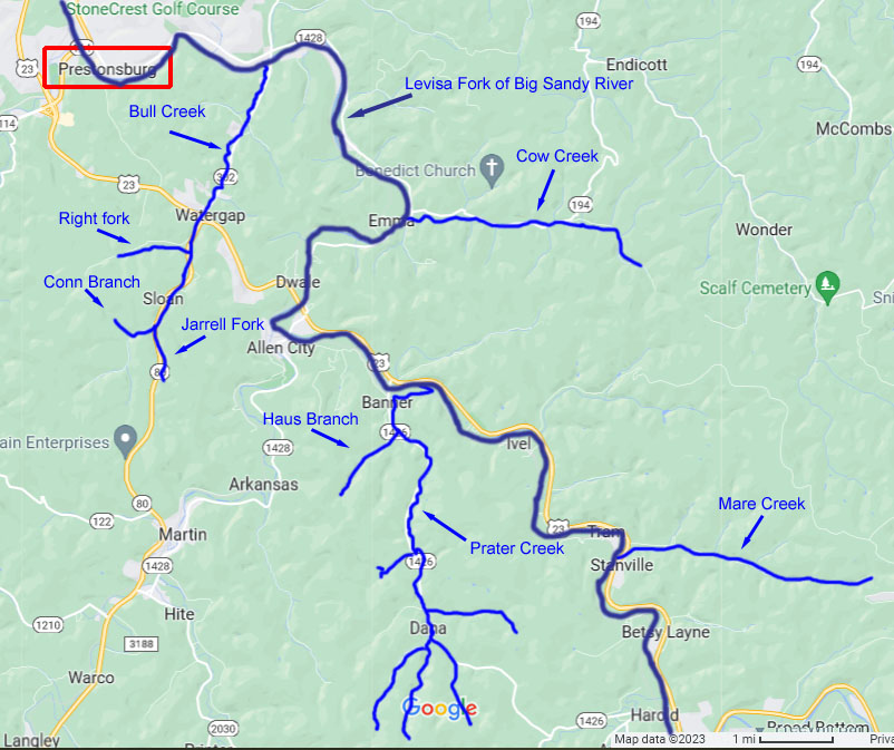
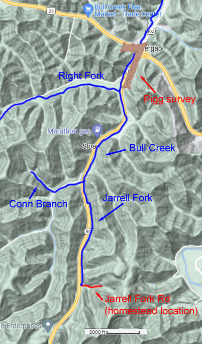
James Pigg was not a Jarrell, but he had Jarrell connections. There is a 200 year old rumor saying that Pigg was the father of Mary Jarrell's children, and DNA evidence is indicating that it's true (at least in the case of her son Ansel). In 1825 Pigg received a 50-acre land grant on Bull Creek (Floyd County Surveys Book A pg 476). There were clearly some Jarrells in the vicinity at some point in time - note the names Jarrell Fork and Jarrell Fork Road on the map at left. Jarrell descendants report that there was a family homestead on Jarrell Fork Road. The 1830 census indicates that Pigg wasn't living too far away from some of the Jarrell family; it shows William Junior, Michael Crum (Vashti's husband), Carroll, Agga, and Ruel near the top of the page, and James Pigg a few lines later in the middle of the page. This is on page 84 of the Floyd County census, and Polly Jarrell's entry is on page 94, close to the entry for Parks Jarrell. So it doesn't look like she was living near Pigg in 1830, and their relationship may have ended several years earlier. Ansel was born around 1819 and Polly's youngest child Nelly was born around 1821; at the moment we don't have DNA evidence that Pigg was Nelly's father. But the situation may not be so clear cut as that. The Kentucky Land Warrants and the Floyd County grantor and grantee indexes indicate that the Bull Creek property was the only land that Pigg owned in 1830, so presumably that's where he was living. He had a wife and children (7 of them in 1830), and they needed a stable home. But the grantor and grantee indexes don't show any Jarrell land ownership on Bull Creek until the 1890s, and we don't know when the Jarrells first moved into this area. The heirs of Susannah Parks Jarrell didn't sell her Prater Creek land grants until 1832-1834; did they find a new home before that? Ruel Jarrell (one of Pigg's sort-of neighbors in 1830) continued to own land on Prater Creek into the 1860s. There's no indication that Pigg ever lived near Prater Creek. It's unlikely that the census taker jumped from Prater Creek to Bull Creek on the same page - there's too much distance between them. Apparently there was no one else in the county named Pigg; the Piggs were Virginians, and James moved to Floyd sometime in the 1817-1819 timeframe. Pigg sold his Bull Creek land in 1832 (Floyd County Deeds Book C page 340), and 1830 is the only year that the census shows him living near the Jarrells. The 1820 census (page 36) shows Levi Conn (Nancy Jarrell's husband), Caroll Jarrell, Ansel Jarrell, Susannah Crisp, Jane Jarrell and Polly Jarrell all living in close proximity, presumably on Prater Creek. Pigg is a few pages earlier, on page 32. Floyd County Order Book 4 page 11 and the Annals of Floyd County page 192 indicate that Pigg was living on Cow Creek in 1821, so that might be where he was in 1820. But he had an excellent opportunity to meet the Prater Creek Jarrells in 1819, when he was appointed to survey the road from the mouth of Prater to the Floyd County courthouse (Annals of Floyd County page 180, Floyd County Order Book 3 page 87). Pigg bought some land on Sandy River in 1831 (Floyd County Deeds Book C page 345) and 1832 (Floyd County Deeds Book C page 357) in addition to a 50-acre land grant there in 1836 (Kentucky Land Warrants). So that's probably where he was living on the 1840 census. By 1850 he had left Floyd County and was living in Lawrence County. The Jarrells seem to have been more scattered in 1840 than they were in 1830, but apparently none of them were living close to Pigg.
|
|
Other family history articles: |
|
Article by Carolyn H (a descendant of Mary "Polly" Jarrell through her son Ansel) 2023 All rights reserved |